Tuesday, November 30, 2004

Auckland Sky Tower Jump

My flight from Wellington arrived at 1 pm, and my flight home departed at 7:40 pm. I didn't want to waste the afternoon sitting in the airport, so I stored my bag, bought a return ticket on the city airport bus, and went to the Sky Center.

My goal was to do the Sky Jump! After psyching myself up, I went to the SkyJump booth and signed up. Sky Jump is basically a controlled jump from a 192 meter platform - 630 feet! For comparison, the observation deck of the Space Needle in Seattle is 520 feet.

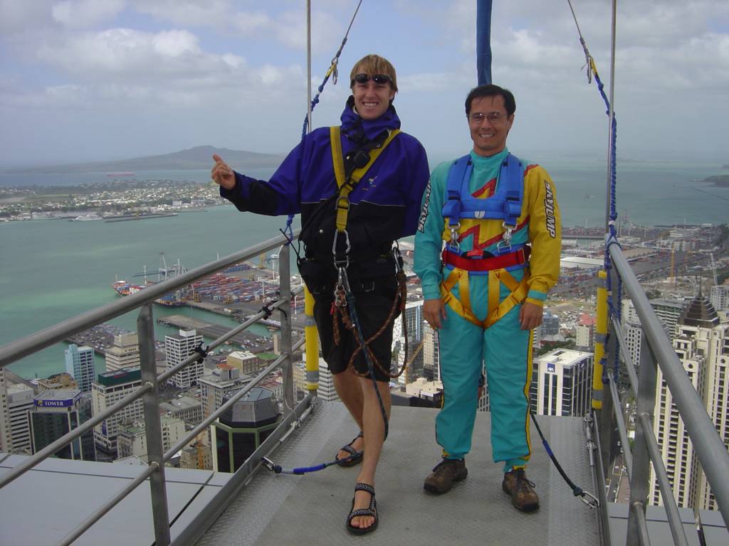
I had to empty my pockets and put everything into a locker. Then, I put on a jump suit that velcroed shut around the ankles and wrists. After this, my SkyJump guide (Erin) placed the harness on me, which was similar to a climbing harness. However, this harness also looped around my shoulders.

Then, Erin walked me to the elevator, punched the button for the skydeck level, and told me how to proceed. I rode the elevator up with a group of tourists, and we alternated looking through various windows on the way up. She didn't ride up, and instead went to the landing platform to wait for me.

At the skydeck level, I found the skyjump platform, and was greeted by two more SkyJump guides. They both double checked my harness, attached a carabiner and rope, and we edged out on the platform.

I was a bit nervous throughout this whole process, but standing on the platform wasn't as bad. This was probably because the SkyJump guides at the upper platform were talking to me to whole time, describing what they were doing and what was about to happen.

On the SkyJump platform...


We walked out to the edge, and they switched around the caribiner to attach me to the drop wire instead of the platform. They adjusted the tension on the drop wire, and I felt it life me up slightly. Then, they said to grab hold onto some ropes, lean out, and then let go.

"Ready Karl? 3, 2, 1, go!"

I was still there clenching the rope with a death grip. After about 5 seconds, I swiveled my head and said "I guess I have to let go, right?"

"Yes. Remember, we'll drop you 20 meters, take a picture, then drop you the rest of the way. Ready now... 3, 2, 1, go!"

This time, I did let go and step off... into freefall, for 20 meters or less. I left the harness tighten and heard my name. I looked up and smiled for a picture, waved, and then was dropped the rest of the way down. It wasn't freefall, but it was extremely exciting!!

I'm flying!! Sort of...


I landed on the outside of the target, and Erin asked me how it was. I said it was really hard to let go of the rope, but I did the second time and thought it was really fun. She then said, we aren't very busy today, so would I like a second jump? For free? After a split second I said yes, and she walked me to the elevator again.

Next time, after all the safety checks, I was able to let go the first time. They paused me briefly at the 20 meter level, which was the observation deck level, and I waved briefly to the people inside, before I was dropped again.

It was an unbelievable adrenalin rush - easily one of the most exciting things I've ever done!

Another Wellington Afternoon

After getting off the ferry, I wandered around more of downtown Wellington, eventually making my way to the government buildings: The Beehive, Parliment, and the Parlimentary Library.

Beehive

The Beehive is the Executive Office Building.

Parliment Library and Garden

The garden commemorates women's suffrage - New Zealand was the first country to allow women to vote.

Church


I walked back to the harbor area and decided to check out Te Papa, the museum of New Zealand. I walked through part of the geological and Maori sections, before meeting my friends.

Drawbridge

Drawbridge with the museum in the background.

Fruit of the Garden


We drove to a different scenic viewpoint, a hill with a wind turbine. Allen and Marybeth then suggested fish and chips for dinner, from the best place they knew of, which was "So Fine" in the Lower Hutt valley. It is near Allen's work, and was highly recommended by locals. We got our dinner takeaway, and then ate it on the waterfront.

Wellington


An extra bonus of going to So Fine for dinner was passing over the river Anduin... I mean, the Hutt River. As my last Lord of the Rings site, I saw where Aragorn was washed ashore after the warg attack.

Monday, November 29, 2004

Picton and Car Games

My travel companions left earlier this morning. For the rest of today and tomorrow, I'm on my own! By not making definite plans too far in advance, I was able to alter my itinerary slightly. I bought a ferry ticket, and booked a flight on Air New Zealand to Auckland. So instead of driving with Krisanne and Eric back to Christchurch, I'm taking the Picton ferry to Wellington, to spend another day there. I'll wander around the city more, and visit my friends. I should be able to burn the contents of my camera to CD and upload more pictures...

Leaving Picton...


Ferry view


Anyway, to keep us occupied in the car, we played various games. There aren't many billboards or other cars on the road, so we wound up playing category games. Such as "bands with animals in their title", "bands with colors in their title", "bands with numbers in their title", "songs about cities", "songs about places", etc. I've found I'm a weak contributor compared to Eric and Krisanne, who are both music savants! As in, I probably came up with 20% of the total, while they each did 40%. So, be sure they are on your team for any music-related game. :)

Abel Tasman

We got up early and I drove us from Nelson to Marahau, "Abel Tasman Village". There, we signed up for a day walk boat trip.

Several companies run aqua taxis, a really cool service. You find a day hike you want to do, and then arrange for the aqua taxi to take you to the drop-off point, and pick you up at your selected location. We decided on a hike from Big Tonga Beach (Onetahuti Beach) to Anchorage.

Split Apple Boulder


Beach at Anchorage


We climbed in the boat, and were towed down the street by a tractor, eventually setting us into the water. The taxi driver first went south, pointing out some scenic spots. First was the beach, covered with a fine golden-brown sand. The color was due to iron oxide (i.e. rust) and the erosion of the rocks. He also pointed out a large boulder in the water which was split in half, called appropriately "split apple boulder". The Maori legend about the boulder is: the land god and Tangaroa (the sea god) were arguing over who owned the boulder. Then the tide was out, it was on the land god's domain. When the tide was in, the sea god claimed ownership. They fought and one threw a spear at the other, striking the boulder and splitting it in half.

Cliffs


Blue water through the trees


The taxi then headed north along the coast, and eventually dropped us off at Big Tonga beach. From there, we made our way along the very well maintained and marked trails south, towards Anchorage. The views and scenery was amazing, even after the trail turned inland. We walked at an easy pace, and found time to sun ourselves on some boulders along the way.

Waterfall near boulders


View away from the waterfall


Eventually we got to Torrent Bay, just across from Anchorage. It was early afternoon, and the tide was going out, so the low tide path was available. Krisanne opted to take that path, while Eric and I wanted to hike a bit more so we did the high tide path. Supposedly, the low tide path takes 20 minutes to cross, and the high tide path takes 1 hour 30 minutes. After walking a bit, we saw Krisanne down below, wading along the sandbar. We thought we could play a trick on her and beat her to our destination if we picked up the pace... so we started to run. It was quite nice as far as trail runs go, but after about 25% of the total distance (2.4 km) we hit a very long hill up, and we were reduced to walking the rest of the way.

Sandbar


Our private beach!


When we got to the beach at Anchorage, we spotted Krisanne laying out enjoying the beach. She seemed surprised we got there so quick... she had arrived just 5 minutes earlier. She said the low tide crossing was very slow due to broken shells, so she had to pick her steps carefully. Eventually we fessed up that we really picked up the pace and ran for a large chunk of the distance. Eric and I wound up covering the distance in about 50 minutes. We were out for a total of 5 hours, and with various breaks, we probably wound up hiking/walking around 4 and a half hours.

After leaving Abel Tasman, we drove to Picton.

Saturday, November 27, 2004

Punakaiki

We didn't do much today other than drive to Nelson, on the north shore of the south island. Along the way, we stopped at Punakaiki, where there are pancake rocks and blowholes to see.

The pancake rocks are a limestone formation - layers of sediment pressed into what looks like stacks of pancakes. The blowholes are chambers where the tide enters, and then sprays out the top, like a whale exhaling. We took the basic walk on the scenic path, and looked out over as the waves washed against cliffs and crags. After taking a bunch of photos, we got back in the car and continued along the highway.

Pancake Rocks


Rocky outcropping


Blowhole before...


Blowhole after


More pancakes!


I caught a rainbow!


We came to a canyon suspension bridge which offered a zip-line ride. However, their credit card machine wasn't working so I couldn't buy a ticket. I could have payed cash but I decided not to do that and instead save cash for places that required it. That was a good call as the Thai restaurant we ate at tonight only took cash (or EFTPOS, the NZ direct debit network, but none of our cards work on that).

Friday, November 26, 2004

Otira Valley Hike

Today we opted to hike in Arthur's Pass, in between Greymouth and Christchurch.

At the visitor's center, we found a nice 2 hour hike in the Otira Valley, which led to a false glacier. The terrain was rocky and gorgeous like everything here, and we made it to the false glacier (looks like a glacier, but is only snow and not ice). It was a perfect day for a hike - sunny with a few clouds. Since it has been raining off and on for the last week, including yesterday, we counted ourselves very lucky!

The view in...


Krisanne blazes a trail


False Glacier


View out...


Blackwater Rafting

Krisanne and I drove up to Charleston to try out blackwater rafting. This is basically tubing in a cave.

Brave cave explorers


Most of the tour was walking around inside the cave. Unlike the Haggas Honking Holes tour I did, this trip wasn't as active - no abseiling (rappeling), not as much climbing and squeezing through narrow spots. There was definitely a lot less crawling on hands and knees through water! However, there were more cave formations to see, and far more glow worms to see.

Looking through stalactites


When we reached the blackwater rafting entry point, we linked our inner tubes together, and the floated backwards for about 400 meters. All the while, hundreds and hundreds of glow worms passed above us, which looked like stars on the night sky. We exited the cave, and then tubed for about half a kilometer to the river exit spot.

Blackwater Rafting

Thursday, November 25, 2004

Monteiths Brewery

One of the local attractions in Greymouth is the Monteith's Brewery. We took a tour, which was very interesting, but the highlight was definitely the taste test at the finish. We all had small samples of the various beers, and then were left with 15 minutes of "open bar", where we could pour as much of any beer we wanted.

For a $10 tour, that is quite a bargain!

I'm the bartender!

Wednesday, November 24, 2004

Fox Glacier and Franz Josef Glacier

We stayed the night in Fox Glacier, and walked up to see Fox Glacier and then Franz Josef Glacier in the morning and early afternoon.

Both glaciers were very scenic. I've always seen pictures of snow-covered glaciers (e.g. the ones on Mt. Rainier) but both of these were really easy to see as the surrounding mountains were not snow-covered. Instead, both really did look like a river of ice, frozen as they flowed down.

Fox Glacier


Krisanne and Eric at Fox Glacier


Be careful!


Maori Glacier legend


We spent more time walking around Franz Josef glacier, looking at it from various angles. Eric and I walked up to see towering ice cliff above us, and could see the river of water flowing underneath.

Posing with Franz Josef


Franz Josef Glacier


Step away from the Ice Cave!


Ice boulders


As we left, the clouds parted and more of the glacier became visible. It was almost three distinctive colors: white/gray at the bottom (gray from sand and debris it picked up) to bright blue at the top.

Franz Josef Glacier

Tuesday, November 23, 2004

Canyon Swing

Krisanne and I thought it would be fun to do the Canyon Swing.

Bungee-jumping never really appealed (except to be able to say "yes I would!" to the question "if your friends jumped off a bridge would you do it too?"), but the canyon swing looked interesting.

It was rainy and cool in the morning, and we were having second thoughts. Freefalling for 60 meters followed by a 200 meter swing arc sounded less appealing in the windy rain. But, I decided to go anyway and at 9:15 a.m. I left Eric and Krisanne at the coffee shop and ran to the hostel to pick up my voucher and call for directions.

As I was reaching for the phone, the desk moved. Seconds later, a longer tremor shook us and I realized we just felt an earthquake.

I'm a minor thrill seeker, but I am also willing to back down in the face of an Act of God. So, I cancelled my canyon swing plan on the spot, forfeiting the deposit, but realizing I wouldn't have any fun thinking if the cables needed to be checked, etc.

Instead, Eric and I hiked up from the city to the gondola base. It took us about an hour and a half, but we also wound up taking a 30 minute detour to a log avalance and decided not to negotiate that. At the top, we met Krisanne at the top, warmed up with coffee and then rode down and left for a long drive to Fox Glacier.

Queenstown

Milford Sound

Today we took a day trip to Milford Sound. It is only 80 kilometers from Queenstown, but the highway goes down, over, and around for a total of about 320 kilometers of driving. We signed up with a smaller tour to avoid driving ourselves or staying at Te Anau, a town on the way.

On the way, the driver pointed out various scenic spots along the way. We passed a "Red Tussock Presevation Area", which the government set aside as an example of the way the country looked before farming took over. Red Tussock was the dominant plant, but doesn't have much nutrition for sheep and cows, so early settlers ripped out red tussock and planted grass.

Red Tussock


We also stopped at "The Chasm", "Hollyford Valley Scenic Overlook", and a waterfall. These were all very scenic, but nothing compared to Milford Sound itself.

Near Falls Creek


The guide informed us a sound is formed from a mountain range rising up from the sea floor, while a fjord is carved from glaciers. In any case, Milford Sound is a World Heritage Site, and will be preserved for the future.

It rained, as it does fairly often, so we were treated to dozens and dozens of waterfalls, which looked spectacular cascading down the sheer cliffs. The mountain side was covered with trees, and the two hour cruise passed by quickly as we stared all around at the beauty.

I took a zillion pictures and really hope they turned out!

Milford Sound


Waterfalls


Cliffs


Dale Point


Stirling Falls


Sunday, November 21, 2004

Safari of the Rings

First, Queenstown is beautiful. It is easy to see great scenery - just drive. If there is a paved road that goes up a hill, take it. If the road is unpaved and you have a 4 wheel drive, take it. You are guarenteed some arrive at some scenic vista!

I decided it would be fun to take a scenic tour and also visit a few sites Lord of the Rings was filmed at, so I went on a Lord of the Rings Safari, while Krisanne and Eric went wine tasting.

The tour started at the nearby Remarkables mountain range, which were used as background for various scenes. We had a view of Deer Park Heights, where the warg attack was filmed. Several other minor scenes were filmed there as well.

The Remarkables


Deer Park Heights


We visited a site near the Kawarau bridge (site of the first commercial bungie jumping company in the world) where the "Pillars of the Kings" scene was filmed. Of course, the background and statues were digitally added, but the site is fairly recognizable.

Kawarau River bungee site


Pillars of the Kings


Then, we went to nearby Arrowtown where the "Ford of Bruinen" (Ringwraiths got washed away by Arwen) and "Gladden Woods" (Isildur rides a horse after taking the ring) scenes were filmed.

Ford of Bruinen


Gladden Woods


After this, the tour climbed into some very rugged terrain, to Skippers Canyon. The road was a narrow one lane dirt road the wound along into steep valleys. I took lots of pictures and hope they give a proper sense of how beautiful it was!

Skippers Canyon


Remarkables